NEW DELHI, India | September 25, 2026 —
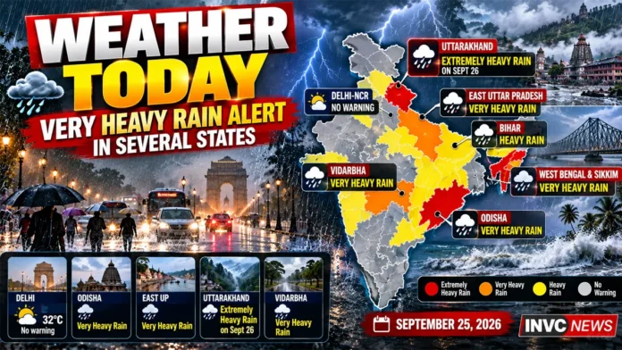
A powerful late-September rain spell is sweeping across parts of India today as a deep depression over South Odisha and adjoining South Chhattisgarh keeps the monsoon active across eastern and central regions.
The India Meteorological Department has warned of very heavy rainfall in parts of Odisha, East Uttar Pradesh, Vidarbha and Sub-Himalayan West Bengal and Sikkim on Friday, while heavy rain and thunderstorms threaten several neighbouring states.
Delhi, meanwhile, is waking up to hazy conditions without a weather warning for the day.
The bigger concern is shifting toward the hills.
Uttarakhand faces heavy rain today, but IMD’s forecast becomes significantly more serious on Saturday, when extremely heavy rainfall is expected at isolated places.
THE 60-SECOND BRIEF
Odisha: Very heavy rain with thunderstorms and lightning.
East Uttar Pradesh: Very heavy rainfall, thunderstorms and lightning.
West Uttar Pradesh: Heavy rain likely.
Uttarakhand: Heavy rain today; extremely heavy rain threat on September 26.
Vidarbha: Very heavy rain possible.
Sub-Himalayan West Bengal and Sikkim: Very heavy rain.
Gangetic West Bengal: Heavy rain and thunderstorms.
Bihar: Heavy rainfall with lightning risk.
Jharkhand: Heavy rain and thunderstorms.
Delhi-NCR: No IMD warning today.
Deep Depression Keeps Rain Belt Active
The main weather driver is a deep depression that moved inland after affecting the North Andhra Pradesh-South Odisha region.
IMD tracked the system over South Odisha and adjoining South Chhattisgarh early Friday.
Although such systems generally weaken after moving over land, they can continue carrying enormous amounts of moisture deep into central and northern India.
That is why the impact is no longer confined to coastal Odisha or Andhra Pradesh.
Rainfall associated with the system is spreading across a broad corridor covering eastern, central and parts of northern India.
Odisha Remains in the Firing Line
Odisha remains one of the states facing the strongest rainfall threat today.
IMD has warned of very heavy rainfall, accompanied by thunderstorms and lightning.
The coastal and interior districts have already been affected by the system that moved across the region.
Persistent rain raises the risk of local flooding, waterlogging, overflowing drains and disruption on vulnerable roads.
People living in low-lying areas should pay particular attention to local district-level warnings.
East Uttar Pradesh Faces Very Heavy Rain
The rain belt has also shifted strongly toward Uttar Pradesh.
IMD has forecast very heavy rainfall over East Uttar Pradesh today, along with thunderstorms and lightning.
The warning continues into Saturday.
West Uttar Pradesh is also under a heavy-rain warning today.
This means commuters, farmers and residents in vulnerable districts should not judge conditions only by the weather visible early in the morning.
Thunderstorm activity can intensify quickly during an active monsoon spell.
Uttarakhand: Today Is Only the Beginning
Uttarakhand deserves special attention.
IMD has issued a heavy-rain warning for the state today.
But the forecast becomes considerably more serious on September 26, when isolated extremely heavy rainfall is expected.
Very heavy rain is also forecast for September 27, followed by heavy rain on September 28.
This multi-day spell can increase the risk of landslides, falling rocks, swollen mountain streams and road disruption in vulnerable Himalayan areas.
Travellers heading toward hill districts should check local road and weather advisories before departure.
Bengal and Sikkim Also Face Intense Rain
Sub-Himalayan West Bengal and Sikkim face very heavy rainfall today, according to IMD.
Gangetic West Bengal is also under a heavy-rain and thunderstorm warning.
The combination of persistent moisture, thunderstorms and saturated local conditions can cause sharp differences in rainfall even across relatively short distances.
One district may receive moderate showers while another nearby location experiences a much more intense downpour.
Bihar and Jharkhand Under Rain and Lightning Threat
Bihar faces heavy rainfall accompanied by thunderstorms and lightning today.
Jharkhand also remains under a heavy-rain warning.
Lightning is one of the most immediate dangers during intense monsoon thunderstorms.
People working outdoors should avoid open fields, isolated trees, rooftops and exposed locations when thunder is heard.
Vidarbha Faces Another Very Wet Day
Vidarbha is also in the high-impact rain zone.
IMD has forecast very heavy rainfall along with thunderstorms and lightning.
Heavy rain is expected to continue into Saturday before conditions begin easing.
Persistent downpours may affect road travel, low-lying neighbourhoods and agricultural areas where the soil is already saturated.
Delhi-NCR: No Rain Warning Today
Delhi-NCR presents a very different picture.
IMD has issued no weather warning for Haryana, Chandigarh and Delhi today.
Delhi is starting Friday with hazy sunshine and temperatures expected to rise to around 32°C, with the minimum near 22°C.
That does not mean isolated cloud development is impossible, but there is no major IMD warning for the capital today.
For Delhi residents, the more noticeable feature may be humidity and haze rather than disruptive rainfall.
Delhi Weather Today
Current conditions in Delhi early Friday are relatively comfortable compared with the intense rain zones farther east.
The capital is expected to see hazy sunshine through much of the day.
Temperatures may reach around 32°C.
The weekend could bring more cloud development, with the possibility of showers increasing by Sunday.
WHY IT MATTERS
Late-September weather can be deceptive.
The monsoon may appear to be nearing its seasonal withdrawal from some regions, but a single strong Bay of Bengal system can rapidly revive rainfall across a huge part of the country.
That is exactly why today’s forecast matters.
The strongest weather is not concentrated in one state.
Instead, the risk stretches from Odisha and Vidarbha through Bihar and Uttar Pradesh to the Himalayan foothills.
Such a broad rain belt can affect highways, rail movement, crops, urban drainage and hill travel simultaneously.
WHAT PEOPLE SHOULD WATCH TODAY
People in very-heavy-rain zones should watch for rapidly rising local streams and drains.
Avoid driving through waterlogged underpasses or roads where the depth of water cannot be judged.
During thunderstorms, move indoors and stay away from exposed open spaces.
In hill areas, avoid unnecessary travel during intense rainfall because landslides can occur with little warning.
Farmers should follow district-level agricultural and weather advisories because rainfall intensity can vary substantially within the same state.
THE BIGGER PICTURE
The current spell shows why the monsoon story does not end simply because September is approaching its close.
Moisture-loaded systems from the Bay of Bengal can continue producing significant rainfall well into the late monsoon period.
The current depression has already influenced weather over the Andhra Pradesh-Odisha region and is now helping drive rainfall deeper inland.
The focus therefore shifts with the system.
Coastal impact comes first.
Then central India.
Then parts of the Gangetic plains and the Himalayan region can feel the effect.
WHAT HAPPENS NEXT
The next 48 hours will be critical.
Uttarakhand is forecast to face an escalation from heavy rain today to extremely heavy rainfall at isolated places on Saturday.
East Uttar Pradesh remains under a very-heavy-rain warning on Saturday as well.
West Uttar Pradesh is expected to continue seeing heavy rain.
Himachal Pradesh, which has no major rain warning today, is expected to enter a wetter phase from Saturday, with very heavy rain possible on Sunday.
Odisha, meanwhile, should begin seeing the intensity ease as the weather system weakens and moves farther inland.
INVC NEWS BOTTOM LINE
India’s weather map is sharply divided today.
Delhi and parts of northwest India remain comparatively quiet.
But from Odisha and Vidarbha to Bengal, Bihar and Uttar Pradesh, an active monsoon system is keeping the atmosphere unstable.
The most important development to watch is Uttarakhand.
Heavy rain begins today, but Saturday could bring a much more dangerous spell.
For millions of people across the affected states, today is a day to watch the sky — and the local IMD warning — closely.