By Team INVC | INVC NEWS
Published: August 29, 2026, 8:34 AM IST
NEW DELHI, INDIA | August 29, 2026 —
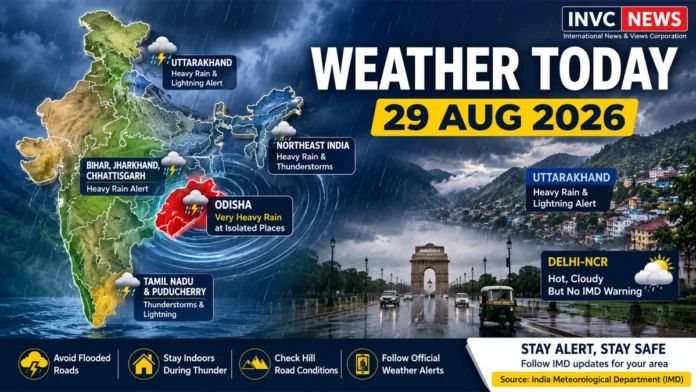
India Weather Today August 29 2026 is being dominated by an active monsoon spell across eastern and northeastern India, with the India Meteorological Department forecasting isolated very heavy rainfall over Odisha and heavy rain across several other states.
Bihar, Jharkhand, Chhattisgarh, Uttarakhand, Gangetic West Bengal, Sikkim and parts of the Northeast are among the regions facing a higher rain risk today.
Thunderstorms, lightning and gusty winds may accompany rainfall in several areas, increasing the risk of waterlogging, traffic disruption and localized flooding.
However, the weather picture is not equally severe everywhere. Large parts of western India currently carry no subdivision-level severe-weather warning, while rainfall activity over Peninsular India is expected to remain comparatively subdued during the coming week.
Odisha Faces the Strongest Rain Threat Today
Odisha stands out in today’s national forecast, with heavy to very heavy rainfall possible at isolated locations.
Residents in vulnerable low-lying areas should remain alert for rapidly rising water, localized flooding and reduced visibility during intense spells.
Bhubaneswar was already experiencing rainy conditions early Saturday morning, underlining the active weather pattern over the state.
People travelling across Odisha should check local district-level alerts before beginning long road journeys, especially if their route passes through flood-prone areas.
Bihar, Jharkhand and Chhattisgarh Under Heavy Rain Risk
Eastern India remains one of the main monsoon hotspots today.
Heavy rainfall is possible at isolated places over:
- Bihar
- Jharkhand
- Chhattisgarh
- Gangetic West Bengal
- East Madhya Pradesh
- Sikkim
Thunderstorms and lightning may accompany rain in parts of the region.
The impact can vary sharply even within the same state. One district may receive only moderate rain while another experiences a short but intense downpour.
Drivers should therefore avoid assuming that clear weather at the starting point guarantees safe conditions throughout a journey.
Also Read – : India Weather Today August 23: Very Heavy Rain Alert for Odisha and Chhattisgarh
Uttarakhand: Heavy Rain and Lightning Alert
Uttarakhand remains under an active weather warning today.
The latest IMD subdivision forecast lists heavy rain along with thunderstorms and lightning for August 29.
The concern becomes even greater over the next few days, with very heavy rainfall appearing in the forecast for August 31 and September 1.
Travellers heading toward hill districts should watch for:
- Landslides
- Falling rocks
- Sudden road closures
- Rising streams
- Poor visibility
- Lightning during thunderstorms
People should avoid stopping vehicles near unstable slopes or swollen rivers during intense rainfall.
Northeast India Faces Widespread Rain
The Northeast is also likely to experience an active monsoon day.
Heavy rainfall is forecast at isolated locations across parts of:
Arunachal Pradesh, Assam, Meghalaya, Nagaland, Manipur, Mizoram and Tripura.
Nagaland, Manipur, Mizoram and Tripura remain under heavy-rain and thunderstorm warnings not only today but through several days ahead.
Repeated rainfall can increase the risk of localized flooding and landslides in hilly terrain.
Delhi-NCR Weather Today: Hot, Cloudy but No IMD Warning
Delhi-NCR has a significantly quieter official warning picture.
The latest IMD subdivision warning for Haryana, Chandigarh and Delhi shows no severe-weather warning for August 29.
Delhi is expected to remain warm, with the maximum temperature around 36°C and the minimum near 26°C.
Partly cloudy or hazy conditions may prevail.
This does not mean an isolated cloud or brief shower is impossible. It means Delhi is not currently under a subdivision-level heavy-rain, thunderstorm or other severe-weather warning for today.
That distinction is important because broad national rain forecasts should not automatically be interpreted as a heavy-rain alert for every city.
Rajasthan, Gujarat and Maharashtra See Quieter Warning Map
The latest subdivision warnings also show no severe-weather warning today for:
- East Rajasthan
- West Rajasthan
- Gujarat Region
- Saurashtra and Kutch
- Konkan and Goa
- Madhya Maharashtra
- Marathwada
- Vidarbha
Again, “no warning” does not mean completely dry weather.
Localized clouds or light rain can still occur. It simply indicates that conditions currently do not meet the threshold for an official subdivision-level severe-weather warning.
Tamil Nadu May See Thunderstorms and Lightning
Southern India presents a mixed picture.
The broader outlook indicates that rainfall activity over Peninsular India is likely to remain subdued during the coming week.
However, Tamil Nadu and Puducherry carry a thunderstorm and lightning warning for today, meaning localized intense weather can still develop even during a generally quieter regional phase.
People outdoors should move to a safe indoor location when thunder is heard and avoid isolated trees, open fields and exposed rooftops.
Where Is the Biggest Weather Risk Today?
For August 29, the most important areas to watch are:
Highest rain concern: Odisha
Heavy-rain watch: Bihar, Jharkhand, Chhattisgarh, Uttarakhand, Gangetic West Bengal, Sikkim and parts of the Northeast
Thunderstorm concern: Tamil Nadu and several eastern/northeastern regions
Relatively quieter official warning picture: Delhi-NCR, Rajasthan, Gujarat and much of Maharashtra
The forecast can change during the day as thunderstorms develop, so district-level nowcasts remain important.
Safety Advisory for Heavy Rain and Lightning
People in rain-alert areas should follow a few basic precautions:
- Avoid flooded underpasses and waterlogged roads.
- Never drive through fast-moving floodwater.
- Move indoors when thunder or lightning develops.
- Keep away from isolated trees, electric poles and open fields.
- Check hill-road conditions before travelling in Uttarakhand or the Northeast.
- Follow official district-level weather and disaster-management alerts.
The IMD’s latest warning information can be checked directly at:
https://mausam.imd.gov.in/responsive/subDivisionWiseWarning.php
India Weather Today: What to Watch Next
The monsoon is not behaving uniformly across India.
Eastern and northeastern states remain the main focus today, while parts of western and peninsular India are seeing a comparatively quieter warning pattern.
For Odisha, Bihar, Jharkhand, Uttarakhand and the Northeast, the key concern is not simply whether it rains—it is whether localized intense spells trigger flooding, lightning incidents or travel disruption.
INVC NEWS will continue to track fresh IMD nowcasts and significant changes through the day.