NEW DELHI, India | August 27, 2026 —
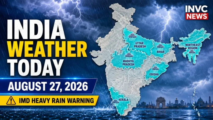
India Weather Today August 27 2026 remains dominated by an active monsoon pattern, with the India Meteorological Department warning of isolated heavy rainfall across Uttar Pradesh, Madhya Pradesh, Bihar, Odisha, Kerala and several northeastern states.
The latest national weather bulletin also flags a low-to-moderate flash-flood risk in parts of Uttar Pradesh and Madhya Pradesh, making waterlogging, surface runoff and localized inundation important concerns through Thursday.
At the same time, the weather picture is far from uniform. Delhi-NCR is expected to see a comparatively quieter day, while rainfall activity over Rajasthan is forecast to weaken from August 27.
Heavy Rain Warning Across Several States Today
According to the IMD forecast valid for August 27, isolated heavy rainfall is very likely over:
- Arunachal Pradesh
- Assam and Meghalaya
- Bihar
- Chhattisgarh
- Jharkhand
- Kerala and Mahe
- Madhya Pradesh
- Nagaland, Manipur, Mizoram and Tripura
- Odisha
- Sub-Himalayan West Bengal and Sikkim
- Uttar Pradesh
Thunderstorms accompanied by lightning are also possible over parts of Madhya Pradesh, Chhattisgarh, Uttarakhand, East Rajasthan and the Northeast.
The widespread rain pattern is being supported by an active monsoon trough and multiple cyclonic circulations. The IMD said a low-pressure area was positioned over southeast Uttar Pradesh and adjoining areas on Wednesday evening, while another upper-air circulation persisted over northwest Madhya Pradesh.
UP Weather Today: Heavy Rain and Flash-Flood Risk
Uttar Pradesh remains one of the most important weather zones to watch today.
The IMD expects isolated heavy rain over the state on August 27. East Uttar Pradesh is likely to receive fairly widespread rainfall, while conditions over western Uttar Pradesh are expected to become less widespread compared with Wednesday.
More importantly, the flash-flood outlook identifies Auraiya, Hamirpur and Jhansi among districts where a low-to-moderate flash-flood risk could develop.
Residents in low-lying areas should remain cautious around overflowing drains, underpasses and waterlogged roads.
Madhya Pradesh Weather: Several Districts Face Flash-Flood Risk
Madhya Pradesh is another major focus today.
Heavy rainfall is forecast at isolated locations, while thunderstorms and lightning may affect parts of the state.
The IMD flash-flood outlook identifies several districts in both eastern and western Madhya Pradesh.
In East Madhya Pradesh, areas of concern include Chhatarpur, Chhindwara, Tikamgarh, Damoh, Jabalpur, Katni, Narsinghpur, Panna and Sagar.
In West Madhya Pradesh, the outlook includes Ashoknagar, Bhind, Datia, Guna, Gwalior, Narmadapuram, Shivpuri and Vidisha.
The weather agency warned that surface runoff and localized inundation could occur over saturated soils and low-lying areas.
Bihar, Jharkhand and Odisha Rain Forecast
Eastern India continues to experience an active monsoon phase.
Bihar may see fairly widespread rain today along with isolated heavy spells. Jharkhand is also under a heavy-rain warning, while Odisha could receive fairly widespread rainfall.
Thunderstorms accompanied by gusty winds of around 30–40 kmph, gusting to 50 kmph, are possible at isolated places over Bihar, Jharkhand, Odisha and West Bengal-Sikkim.
The rain threat over Odisha may intensify again over the coming days, with the IMD forecasting isolated heavy to very heavy rainfall in the state from August 29 onward.
Northeast India Weather Today
The Northeast also remains under an active rainfall spell.
Heavy rainfall is likely at isolated locations over Arunachal Pradesh, Assam, Meghalaya, Nagaland, Manipur, Mizoram and Tripura.
Thunderstorms and lightning are also possible across parts of the region.
The IMD expects rainfall activity to remain elevated in several northeastern states through the end of August, with the possibility of heavier spells around August 30.
Kerala Weather: Heavy Rain Still Possible
Kerala and Mahe may receive fairly widespread rainfall today, with isolated heavy rain also possible.
However, the larger national forecast suggests that rainfall distribution over Kerala is likely to become more scattered after August 28.
People in vulnerable low-lying areas should continue monitoring local district-level alerts because short-duration intense rain can produce localized waterlogging even when statewide rainfall is not extreme.
Delhi-NCR Weather Today
Delhi-NCR has a comparatively quieter weather outlook.
The national forecast indicates isolated rainfall over Haryana, Chandigarh and Delhi on August 27 rather than widespread heavy rain.
Early-morning IMD observations showed high humidity across Delhi-NCR, with New Delhi around 28.4°C and relative humidity near 89% at the time of observation.
Therefore, residents should expect warm and humid monsoon conditions, with localized rain still possible.
Rajasthan Weather: Rain Activity Set to Ease
Rainfall activity over Rajasthan is expected to weaken from August 27.
The Jaipur Meteorological Centre said rain activity over eastern Rajasthan is likely to decrease between August 27 and September 2, although parts of the Kota division could still receive light to moderate rainfall on August 27 and 28.
A thunderstorm and lightning warning remains in place for isolated parts of East Rajasthan today, while West Rajasthan carries no major subdivision-level warning.
Also Read – : India Weather Today August 23, 2026: IMD Heavy Rain Alert Across States
Fishermen Warning for August 27
Marine conditions remain hazardous in parts of the Arabian Sea and Bay of Bengal.
Squally winds of 45–55 kmph, gusting to around 65 kmph, are forecast over portions of the Arabian Sea and near the south Tamil Nadu coast, Gulf of Mannar and adjoining southwest Bay of Bengal.
Squally weather with winds reaching 40–50 kmph and gusting to 60 kmph is also expected over parts of the southeast Bay of Bengal and Andaman Sea.
People involved in fishing and marine activities should follow local IMD and coastal authority advisories before entering affected waters.
What to Watch Through August 28–30
The immediate rain threat is expected to gradually shift eastward.
On August 28, heavy rainfall remains possible over Bihar, Odisha, Jharkhand, Chhattisgarh, Sub-Himalayan West Bengal and Sikkim, along with the Northeast.
By August 29 and 30, Odisha and northeastern India could become more important rainfall hotspots, with isolated very heavy rainfall possible in some areas.
For travelers, the biggest practical risks today remain waterlogged roads, reduced visibility, localized flash flooding and lightning.
Readers should check district-level warnings before long road journeys because localized alerts can change quickly during the monsoon.
Official weather updates are available from the India Meteorological Department.