JAKARTA, Indonesia — August 15, 2026
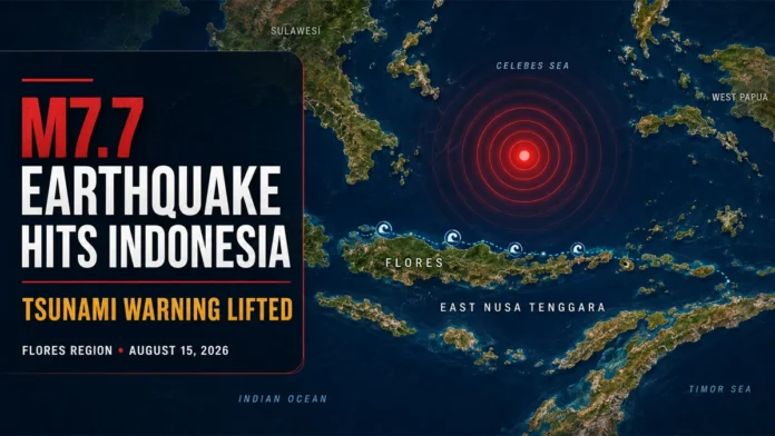
Indonesia earthquake authorities lifted a tsunami warning Saturday after a powerful magnitude 7.7 earthquake struck near Flores Island, killing at least two people and injuring another person.
The shallow offshore earthquake shook communities across East Nusa Tenggara and neighboring parts of Indonesia early Saturday, forcing residents to leave their homes and move away from coastal areas. Officials initially issued a tsunami warning for several provinces before canceling it approximately three hours later after monitoring detected no dangerous sea-level rise.
Indonesia’s National Disaster Mitigation Agency said the two reported deaths and one injury occurred in Sikka Regency. Emergency teams were assessing damaged buildings, transportation links and other infrastructure across the affected region.
The casualty figures and damage assessment remain preliminary and could change as emergency workers reach more remote communities.
Where did the Indonesia earthquake strike?
The earthquake was centered in waters north of Flores Island, approximately 68 kilometers north-northwest of Ende in East Nusa Tenggara province. The initial assessment placed the earthquake at a shallow depth of about 10 kilometers.
Shallow earthquakes can produce stronger surface shaking than deeper events of a similar magnitude. However, the severity of the impact also depends on the earthquake’s location, fault movement, local geology and the strength of nearby buildings.
Earthquake measurements are frequently revised as more seismic data becomes available. The USGS earthquake catalog and Indonesia’s meteorological agency may publish updated estimates for the magnitude, depth and epicenter.
Was a tsunami warning issued?
Indonesia’s Meteorology, Climatology and Geophysics Agency issued a tsunami warning shortly after the earthquake. Coastal residents in the affected warning areas were instructed to stay away from beaches, river mouths and low-lying shorelines and to move toward higher ground.
The warning was later lifted after monitoring showed no significant or destructive sea-level changes. Residents should still follow local emergency instructions because strong aftershocks can cause additional damage or, in some circumstances, lead authorities to issue new coastal advisories.
Officials also said there was no tsunami threat to Australia.
Strong aftershocks shake the Flores region
Several strong aftershocks followed the main earthquake. Indonesia’s official earthquake feed recorded multiple tremors in East Nusa Tenggara, including magnitude 6.2 events near Mbay and Labuan Bajo and other earthquakes near Ruteng. Those individual aftershocks were classified as not having tsunami potential. BMKG’s latest earthquake data showed continued seismic activity across the region.
Aftershocks can continue for days, weeks or longer after a major earthquake. Although they are usually weaker than the main shock, they can bring down structures that were already damaged.
Authorities have advised residents not to enter visibly damaged buildings until they have been inspected. People in affected areas should also watch for falling debris, landslides, damaged roads and disrupted utilities.
Damage assessments underway
Strong shaking was reported across Flores and other parts of East Nusa Tenggara. Initial footage from affected communities showed damaged and collapsed structures, while some hospitals moved patients outdoors as a safety precaution.
Emergency personnel were deployed to evaluate conditions and support rescue operations. Officials were also checking remote settlements where communications and road access may have been disrupted.
No comprehensive estimate of the number of damaged buildings or displaced residents was immediately available.
Why Indonesia experiences powerful earthquakes
Indonesia is located along the Pacific “Ring of Fire,” a seismically active zone where several tectonic plates meet. Movement between these plates regularly produces earthquakes, volcanic eruptions and occasional tsunamis.
The country consists of more than 17,000 islands and has extensive coastal communities, making rapid earthquake and tsunami warnings especially important. Flores has previously experienced damaging earthquakes, including the destructive 1992 earthquake and tsunami.
Residents should rely on verified information from BMKG and local disaster-management authorities rather than unconfirmed social-media posts.